Mobile Topographer Pro 15.0.2
Paid Version
Publisher Description

Mobile Topographer Pro - Can a topographic device fit into your pocket? The choice of the professionals!
Your Mobile Topographer goes... Pro!
The leading tool for the professional surveyor or anyone who wants to mark his property, offering the best accuracy and extensive functionality that no other app can!
Only in Pro:
*** Export data in the standard of GIS Shape files (.shp)
*** Import file
- Import points from file in WGS84 format or CRS of your choice
- Import points from text files (.txt, .csv) or Shape files (.shp)
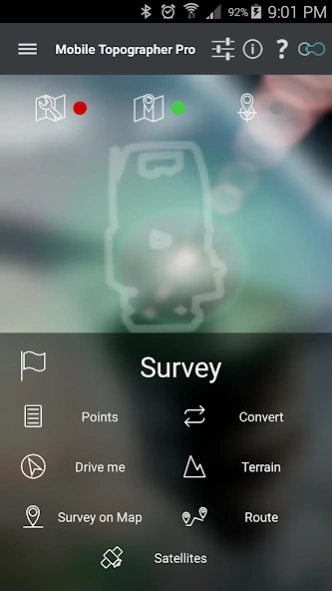
*** 3D Terrain modeling & contours
- Collect terrain data
- Create a 3D terrain model
- Create contours
- Show on map
- Load, save, export 3D terrain model and contours
*** Route tracking
- Track your route
- Process route
- Get statistics
- Show on map
- Load, save, export route
*** Real time map projection while surveying
*** Survey on map.
- Complete a survey without even going to the field
- Insert, modify or delete points directly on the map
- Correct or make additions to an existing survey
*** Group points
- Divide your list of points in groups
- Filter list of points view, by naming groups
- Export list of points with group division or filtering
- Select the contents of the exported lists of points
*** Device Elevation
*** Auto survey mode
*** Area, Perimeter, Number of vertices of polygon
*** Manually edit coordinates of a point
- Key in the new coordinates
- Reposition a point using drag & drop or edit mode
*** Swipe from left to view satellites while surveying
*** View GNSS satellites in Augmented Reality
*** Full functionality even without internet connection
*** Maps v2
*** Weather
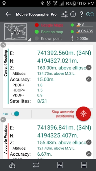
*** Increased accuracy(For even better accuracy, you can link your device to an external GPS receiver)
Plus the well known features of Mobile Topographer Free:
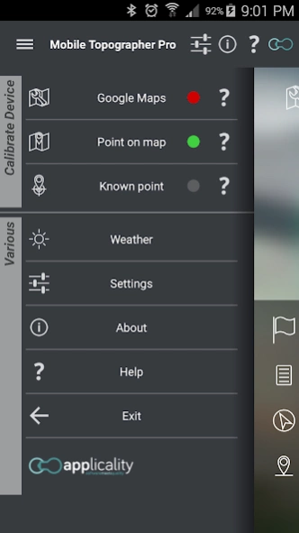
*** Increase GPS accuracy using:
- Weighted averaging (on every axis)
- Map calibration
- Device calibration on map, or on a know point
*** Display and convert GPS geodetic to cartesian EN coordinates and back:
- UTM
- Europe ETRS89/UTMZ28-38
- Hellas HGRS 87 (GGRS87 - EGSA 87 - ΕΓΣΑ 87)
- Hellas HGRS 87 (HEPOS)
- Hellas HTRS07/TM07
- Morocco Merchich CS
- SPCS83 (124 zones) USA
- Brazil & Central and South America SIRGAS 2000
- Brazil SAD69/UTM Z18-25 & SAD69(96)/UTM Z18-25
- Australia MGA94 & AMG66 National, A.C.T., Northern Territory, NSW & Victoria, Tasmania & AMG84 (AGD84)
- Italy Monte Mario West Zn 1 Peninsular, West Zn 1 Sardinia, East Zn 2 Peninsular, East Zn 2 Sicily
- Spain ED50/UTMZ29-30 NW, ED50/UTMZ29-31 ML, ED50/UTMZ31 BA.
- Uk's OSTN02/OSGM02
- Turkey ED 50/Gauss-Kruger 3° Z9-15 & ITRF96 & ED50/UTMZ35-38
- Argentina POSGAR 94 & POSGAR 2007
- India Kalianpur 1975 ZI - ZIV
- Central and South American SIRGAS 2000
- France RGF93/CC42-50 Auto & manual
- Canada CSRS (19 systems)
- Carthage of Tunisia
and many more... (http://applicality.com/supported-coordinates-reference-systems/)
*** Multiple units support:
- Meters
- International feet
- US survey feet
*** Height calculation:
- Ellipsoidal height
- EGM96 orthometric height
*** Convert from geodetic to cartesian coordinates and back:
- Support for device measured points, or
- Manually input of geodetic or cartesian coords
*** Drive me:
- Key in coordinates of a target point in either geodetic or cartesian format, or select a point from the list and follow the pointer.
- Compass indicating both magnetic and true North
*** Project on Map:
- Project individual points on any map application
- Project list of points, and the defined polygon, on embedded Google maps
*** Save multiple point lists.
*** Calculate area.
*** Export point lists to:
- .txt (text file)
- .csv (point file - comma separated)
- .kml (google earth file)
- .gpx (GPS Exchange format)
- .dxf (drawing file)
- .shp (shape files)
*** Send file via e-mail, or upload it to cloud
*** Satellites sky view
*** Signal strength and number of satellites indication for each GNSS constellation
*** Support of all GNSS constellations:
- GPS
- GLONASS
- QZSS
- BEIDOU
- GALILEO
*** Complete help text support
About Mobile Topographer Pro
Mobile Topographer Pro is a paid app for Android published in the PIMS & Calendars list of apps, part of Business.
The company that develops Mobile Topographer Pro is applicality. The latest version released by its developer is 15.0.2. This app was rated by 1 users of our site and has an average rating of 1.5.
To install Mobile Topographer Pro on your Android device, just click the green Continue To App button above to start the installation process. The app is listed on our website since 2023-05-15 and was downloaded 924 times. We have already checked if the download link is safe, however for your own protection we recommend that you scan the downloaded app with your antivirus. Your antivirus may detect the Mobile Topographer Pro as malware as malware if the download link to gr.stgrdev.mobiletopographerpro is broken.
How to install Mobile Topographer Pro on your Android device:
- Click on the Continue To App button on our website. This will redirect you to Google Play.
- Once the Mobile Topographer Pro is shown in the Google Play listing of your Android device, you can start its download and installation. Tap on the Install button located below the search bar and to the right of the app icon.
- A pop-up window with the permissions required by Mobile Topographer Pro will be shown. Click on Accept to continue the process.
- Mobile Topographer Pro will be downloaded onto your device, displaying a progress. Once the download completes, the installation will start and you'll get a notification after the installation is finished.
